

The map view in the ‘Location Details’ page shows all nearby tanks and cylinders you have access to within a radius you can set from your profile.
They are visible as pins on the map. Cylinders are represented by a grey pin. Tanks that have a fill level above 40% are green, tanks with a fill level between 20% and 40% are yellow and tanks below 20% are red. Locations with delivery stop orders placed on them are marked orange.
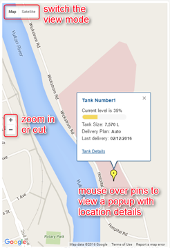
You can switch between satellite and map views using the controls on the top left. Zoom the map in or out from the central left controls.
Filter the visible pins on the map either by searching a keyword, by selecting a province, the propane level percentage or by choosing to only display tanks or cylinders.
Mouse over a pin to get a quick view on the location’s information. Click the “Tank Details” link to be directed to the ‘Location Details’ page:
Comments